
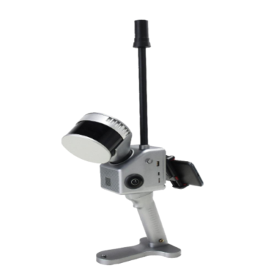
Overview:
The Inventory Master’s handheld LiDAR scanning systems are designed for high-efficiency, portable 3D data capture in a wide range of environments. With a compact and lightweight build, they are easy to carry, simple to operate, and adaptable to various installation needs. These systems integrate advanced GNSS, INS, LiDAR, and SLAM technologies, enabling accurate and seamless data collection across indoor and outdoor settings. Their multi-platform compatibility and sensor-rich design make them ideal for fast and flexible surveying applications.
Features:
- Centimeter-level precision
- 120/300m Range
- Real-time preview of APP
- 270°x360° Field of View
Applications:
- 3D Modeling
- Building Surveying
- Mining Tunnel Survey
- City Park Survey
- Forestry Survey
- Power Line Patrol
- Bridge Survey
- Underground Parking
Technical Specifications:
| General System Performance | |||
| Model | TIMMPS- 221-A | TIMMPS- 221-B | TIMMPS- 221-C |
| Absolute Accuracy | ≤5cm | ≤5cm | ≤5cm |
| Battery Duration | 2h | 2h | 2h |
| Weight | 2.15kg | 2.15kg | 1.7kg |
| Data Storage | 128GB | 128GB | 128GB |
| Battery Capacity | 11600mAh | 11600mAh | 11600mAh |
| Power Consumption | 25W | 25W | 25W |
| Carrying Platform | Handheld, Backpack | Handheld, Backpack | Handheld, Backpack |
| Operating Temperature | -20° ~ +55° | -20° ~ +55° | -20° ~ +55° |
| Voltage | 12V – 18V | 12V – 18V | 12V – 18V |
| POS Performance | |||
| POS Model | gSpin 210 | gSpin 210 | gSpin 210 |
| IMU Update Rate | 200Hz | 200Hz | 200Hz |
| GNSS System | GPS L1/L2/L5; GLONASS L1/L2; GAL E1/E5a/E5b; BDS B1c/B1/B2/B2a/B2b/B3 | ||
| Position Accuracy | 0.020m horizontal, 0.030m vertical | 0.020m horizontal, 0.030m vertical | 0.020m horizontal, 0.030m vertical |
| Pitch Accuracy | 0.015° | 0.015° | 0.015° |
| Roll Accuracy | 0.015° | 0.015° | 0.015° |
| Heading Accuracy | 0.040° | 0.040° | 0.040° |
| Laser Scanner Performance | |||
| Measuring Range | 120m | 120m | 300m |
| Range Accuracy | ±1.5cm | ±1.5cm | ±1cm |
| Laser Line Number | 16-channel | 32-channel | 32-channel |
| Data | 640,000 Points/Sec | 1,280,000 Points/Sec | 1,920,000 Points/Sec |
| Field of View (FOV) | 270°/360° | 270°/360° | 270°/360° |
| Camera | |||
| Resolution | 2×20MP | 2×20MP | 2×20MP |
| Mapping | |||
| Mapping Method | SLAM; RTK-SLAM; PPK-SLAM | ||
| Software | |||
| Point Cloud Creater | Self-developed point cloud preprocessing software | ||
| Point Cloud Automata (Optional) | World-leading point cloud classification and post processing software | ||


Reviews
There are no reviews yet.